Current Time in Page, AZ
(MST)
October 30, 2026
White Pocket, Arizona: How to Visit From Page
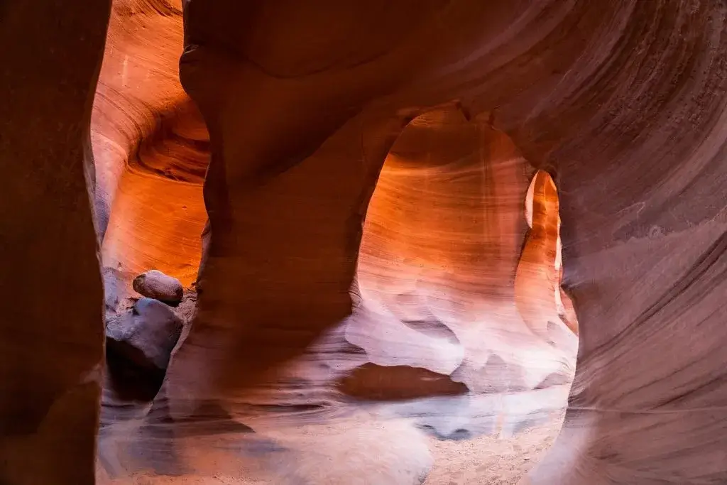
White Pocket is a field of swirled white, orange, and red sandstone in Vermilion Cliffs National Monument, about two hours west of Page, Arizona. Unlike The Wave in the same monument, it does not use a permit lottery. The catch is getting there: the last miles are deep sand that requires a high-clearance four-wheel-drive vehicle, and the Bureau of Land Management says many groups get stuck every year.
Here is what to know before you go, whether you drive yourself or join a guided tour.
White Pocket at a glance
| Where | Vermilion Cliffs National Monument, on the Paria Plateau near the Arizona and Utah line |
| From Page | 36 miles west on US Highway 89, then dirt and sand roads. Plan on about 2 hours each way, often more |
| Vehicle | High-clearance four-wheel drive, required |
| Permit and fee | None at last check, but confirm with the BLM before you go |
| Trails | None developed. You explore open slickrock from the parking area |
| Services | No water, no gas past the highway, and no cell service at White Pocket |
| Managed by | BLM Arizona Strip Field Office, (435) 688-3200 |
What is White Pocket?
White Pocket is an expanse of slickrock where minerals and weather have left bands and swirls of white, cream, orange, and red across the stone. The formations look like frozen waves, brain coral, and poured batter, and they change color through the day. It is a favorite of landscape photographers, and it feels wilder than most places in the region, with no railings, no paved paths, and often few people.
There are no developed trails. From the parking area, a path heads west for about 100 yards to the rock, and from there you explore on your own.
White Pocket vs The Wave
Both sit in Vermilion Cliffs National Monument, and both are famous for swirled sandstone. The difference is access:
- The Wave, in Coyote Buttes North, can only be visited with a permit won through a lottery, and only a small number of people get one each day. Our guide explains how The Wave permit lottery works.
- White Pocket has no permit lottery. Anyone who can get there can go, which is why the hard part is the drive rather than the paperwork.
White Pocket had no entrance fee at last check, though the BLM has considered adding a recreation fee. Check the BLM's White Pocket page before you go.
How to get to White Pocket from Page
These directions follow the BLM's own route description:
- From Page, take US Highway 89 west for 36 miles to the north end of House Rock Valley Road (BLM 1065).
- Drive south on House Rock Valley Road for 23.5 miles to BLM 1017. Coming from the south instead, the road starts at Highway 89A, 13.5 miles east of Jacob Lake, and BLM 1017 is 9.3 miles north.
- Follow BLM 1017 east for 6.2 miles, then head northeast on BLM 1087.
- Where BLM 1087 splits from BLM 1086, stay left to reach the trailhead.
House Rock Valley Road is a graded dirt road. The roads beyond it are where the trouble starts: deep sand and patches of sharp rock. Leave any gates the way you find them.
Before you leave pavement, fill your tank, carry plenty of water, and download offline maps, because there is no gas on House Rock Valley Road and no cell service at White Pocket. Part of the drive crosses into Utah, so from March to early November your phone may jump an hour ahead. Our Page time zone guide explains why.
Should you drive yourself or take a tour?
For most visitors, a guided tour is the better choice. The BLM is blunt about why: many groups get stuck or stranded each year, often because of inexperience or the wrong vehicle, and if you get stuck, break down, or get lost, getting out is your responsibility, not the BLM's or emergency services'.
Drive yourself only if you have a true high-clearance four-wheel-drive vehicle, experience driving in deep sand, and recovery gear. Many rental car agreements do not allow driving on unpaved roads at all, so check yours. If you are unsure, the BLM recommends an authorized guide. Tours run from Page and Kanab, and BLM visitor centers keep a list of authorized guides.
What to expect once you are there
- No shade. The rock is exposed all day. In summer, go early or late, and carry more water than you think you need.
- Easy to lose your bearings. With no trail, the formations start to look alike. Note landmarks or drop a GPS pin at the parking area.
- Best light. Early morning and late afternoon bring out the color and texture, which is why many photographers camp nearby.
- Leave no trace. The BLM reports human waste, toilet paper, and fire rings left behind. Pack out all trash, including food scraps and toilet paper. In sensitive areas, pack out human and pet waste too.
- Camping. Dispersed camping is allowed. Use existing campsites, keep them small, and do not damage trees or collect firewood.
Fitting White Pocket into a trip to Page
White Pocket takes a full day, so plan it for a different day than your canyon tour. A good two-day plan is a Lower Antelope Canyon tour and Horseshoe Bend on one day, and White Pocket on the other.
If you are coming back by way of Highway 89A, the south end of House Rock Valley Road is not far from Navajo Bridge and Lees Ferry, which make an easy stop on the way to Page. For somewhere to stay, see hotels near Antelope Canyon.
When you have your dates, book your Lower Antelope Canyon tour first. Popular tour times fill up, so lock that in before the rest.
We Think You'll Like These
Read More of Dixie



Subscribe to Our Newsletter
Stay connected to the canyon. Get stories, updates, and insider tips delivered to your inbox.